I would recommend that you purchase Charles Tait’s informative guide
before you set out on the coastal touring route that has come to prominence in
the last two years and is known as Scotland’s Route 66. The North Coast 500, as
its name implies, is just over 500 miles in length, starts and finishes in
Inverness, and takes in what must be the most stunning scenery in the UK. Your journey
will take you through picturesque villages, passed mountains, Lochs, glens,
beautiful beaches and cliffs and give you an opportunity to discover castles,
historical sites and other places of interest, which in turn will give you an
intriguing look back into Scottish history.
1st Stage: Inverness.
Our first stop over was at the Torvean
Caravan Park, a very nice independent site run by a very friendly young
man. It’s ideally located at the side of the Caledonian Canal and a short
walking distance from Inverness Town Centre via a very pleasant and picturesque
stroll along side the River Ness.
 |
| Walk along the River Ness. |
The Capital of the Highlands is a great place to start your 500-mile
trip. The first thing that strikes you about Inverness is the amount of
religious buildings, but as well as buildings that cater for various
denominations there are plenty of other interesting places to visit.
 |
| Inverness caters for all donominations. |
Inverness Castle.
On a good day its worth the five pound it costs you to ascend the 94
stairs to the Castle viewpoint to get a breath taking 360-degree view right
across Inverness and the surrounding countryside. You also get a couple of
floors of local legend including how St Columba was responsible for Loch Ness
having its own monster. The castle was blown up by the Jacobite’s in 1746 so
the medieval castle had to be rebuilt and is used today as the local Sheriff’s
Court and therefore the main building is not open to the public.
Flora MacDonald Statue.
Again we meet the Jacobite heroine Flora MacDonald in the form of a
large statue by the Inverness sculptor Andrew Davidson erected in 1899.
The Victorian Market.
This closed in walk through market dates back to around 1890 and has a
grand collection of shops and cafes and is somewhere to go when it’s raining!
Old High St Stephen’s Church.
The original Parish Church of Inverness is where the Government housed
the Jacobite prisoners after the battle of Culloden Moor in 1746. Those
condemned to death were taken out and then executed in the churchyard. Two
stones can be seen, one with two curved hollows and the other with a v-shaped
grove - nine paces apart. The blindfolded prisoner sat on one while the musket
of the executioner rested in the grove of the other. Their bodies were removed
by the ‘poor folk of Inverness’ and unceremoniously thrown into a pit outside
the church boundary.
The graveyard also contains the burial monument of the Robertson's of Inshes,
which is regarded as one of the finest examples of 17th century Scottish
decorative masonry.
 |
| The Jacobite Stone. |
Eden Court Theatre.
Originally opened in 1976 reopened in 2007 following a major revamp, as
the biggest art centre in Scotland containing two theatres, two cinemas, two
dance and drama studios and three floors of purpose built dressing rooms. It
has an unbelievably large programme of advents.
Leakey Bookshop.
With a stock of books said to be over 100000, this independent bookshop
is a real delight, and somewhere you can easily loose a couple of hours
browsing. Housed in what was St Mary’s Gaelic Church this second hand bookshop
is reputed to be the largest in Scotland.
Inverness Botanic Gardens.
Opened by a Royal in 1993 the gardens are described as ‘a oasis of calm
and beauty’, which it certainly is. One of the nicest botanical gardens I have
visited and highly recommended. You will also find a wee cafe that sells great
coffee and cakes.
Camping next to northern section of the Thomas Telford built Caledonian
Canal, this one opened in 1822; it gives you a chance to see the sea lock and
railway swing bridge at Clachnaharry. Walking out to the far end offers some
great views of the Kessock Bridge that carry the main A9 northwards.
2nd Stage: Inverness to
Loch Carron.
On the west side of Inverness across the A9 there is a Tesco Superstore
that has ample parking for large vehicles and a reasonably priced petrol
station so it was an ideal place to stock up for the next stage of the trip.
Although you can cross the Kessock Bridge the recommended route for the Tour of
the North Highlands takes you east out of Inverness via Beauly, Garve and
Achnasheen. Which on a good clear day offers some startling scenery but our
journey was beset by rain and heavy mist so this curtailed our appreciation of the
surroundings.
 |
| Beauly and the Lovat Hotel.. |
 |
| A rather splendid coffee shop in Beauly. |
The picturesque wee village of Beauly lies just 10 miles from Inverness
and boasts some interesting shops along side the remains of a Priory. John
Byset founded the Priory in 1230 for the French order of Valliscaulian monks
who were credited with naming the village. Although it has no roof, the
building is in remarkable condition and remains a popular visitor attraction
with coach party's breaking their tour journeys to view the ancient site.
 |
| The Priory. |
It was still raining when we arrived at The Wee Camp Site, which is a great description of this site! It
has a minimal amount of pitches with an adjoining facilities block that is
quaint to say the least.
When the weather finally improved a walk through the village of Lochcarron,
a former crofting and fishing community on the northwest side of the Loch, was
in order. Previously linked to the oil industry it is now a tourist resort with
a range of accommodation, a general shop and a couple of places to eat. Maybe
it was the weather but Lochcarron is certainly not the most captivating village
on route.
 |
| View across Loch Carron. |
 |
| Lochcarron Main Street. |
3rd Stage: Lochcarron to
Poolewe.
When you leave Lochcarron the route to Inverewe Gardens Camp Site, just north of Poolewe, takes you through
what must be one of the most uninhabited areas in Scotland. Even with the low-lying
cloud, the en-route scenery is spectacular. From Tolrnapress you can appreciate
the hills that surround the road that lead’s up to the village of Applecross
via Bealach na Ba (pass of the cattle) and then you follow the single track
road to Shieldarg, a planned fishing village, then onto Torridon, through the
wonderful Glen of Torridon and then along Loch Maree to Kinlochewe and pick up
the A832 to Gairloch Harbour and on to the Camping and Caravan Site on the
shore of Loch Ewe.
 |
| The weather was not that good! |
 |
| Gairloch Harbour a great place for boat trips. |
The site is well organised and has all the good clean facilities that
you would expect from a CCC site including a laundry that’s a wee bit over
priced at £3:50 a wash.
Poolewe is a tiny village at the head of the Loch Ewe that attracts a
great deal of tourists because of the close vicinity of Inverewe Gardens. The
gardens and house are known as the ‘Oasis of the North’ and have been
administered by the National Trust for Scotland since 1952. Built by Osgood
Mackenzie who purchased the barren hillside in 1862, from then until his death
in 1922 transformed it into magnificent gardens and woodlands. His daughter who
also had the house rebuilt following a devastating fire in 1914 continued his
work; the present house was finished in 1937, and open to visitors from 2016.
The house and garden are a must visit and on a good clear day offer spectacular
views and the chance to see plants and trees from all over the world. The
estate also offers a large car park, a restaurant and a Bothy near the house
where you can purchase coffee and home baking
 |
| The House. |
 |
| The Study. |
 |
| The Gardens |
Situated between the village of Poolewe and Inverewe Gardens is a ruined
chapel which has in it's burial ground a Pictish Stone one of the few found so
far to the west. Also there are many other interesting old gravestones and also
four military war graves. The Kirkyard is still in use today.
 |
| The Ruined Chapel. |
The main wartime use of Loch Ewe was as a rendezvous for ships taking
part in the Artic Convoys to Russia and if you journey up the Cove Road you
will eventually come to what is left of the coastal defences for the ships
anchored in the Loch and a memorial erected by ‘The Russian Convoy Club’ in
memory of those that sailed from the Loch during World War 2 and lost their lives
in the artic sea battles on their way to North Russia. Winston Churchill
described this journey as the “worst journey in the world” over 3000 men lost
their lives in the Artic waters between Scotland and USSR.
 |
| The Memorial. |
 |
| The Defences. |
4th Stage: Poolewe to
Ardmair Point.
Ullapool is the main settlement in the northwest of Scotland and where
you catch the CalMac ferry to Stornaway and the Outer Hebrides. The village
itself, planned by Thomas Telford for the Herring industry, is a popular
tourist attraction with a variety of shops and restaurants including the
Seaforth Hotel and its adjoining fish and chip takeaway. It also has a car park
designed for larger vehicles right next to a Tesco’s Store.
 |
| On the road to Ardmair Point. |
Ardmair Point Camp Site is just
over three miles north of Ullapool and right on the edge of Loch Kanaird
opposite Isle Martin. The campsite is adequate, but quite expensive.
The two nights spent here have been lashed with heavy rain but it did
stop long enough for a walk to Rubha Cadail lighthouse that is near the small
village of Rhue and sits on a peninsular that separates Loch Kanaird and Loch
Broom, the main approach to the port at Ullapool. The lighthouse came into
operation in 1952 and was originally built for the Northern Lighthouse Board
but has since become the responsibility of Ullapool Harbour Trustees. It is
unclear who designed the structure and its light, but does owe some of its
design characteristics to the Stevenson family?
 |
| Views on the walk to the Lighthouse. |
 |
| The Lighthouse. |
5th Stage: Ardmair Point to
Durness.
The journey across remote Sutherland from Ardmair to Durness, the most
northern village on mainland Britain, must be one of the most magnificent
scenic routes anywhere in Scotland. My advice would be to take advantage of the
many ‘scenic view points’ signposted on the route. Its difficult to say which
of the many stops I enjoyed most, but what ever you do make sure time is
allowed for a stop at the edge of Loch Assynt to view the grandeur of what was
Ardvreck Castle.
 |
| The Lonely Lands. |
 |
| Some views are worth waiting for. |
According to the information provided, Ardvreck Castle is the 15th
century seat of the MacLeod’s of Assynt and was built by Angus Mor the 3rd in
the later half of that century. Some time later the castle was enlarged but by
all accounts was still a small structure, needing adjoining buildings to house
kitchens, staff quarters and the stables. The castle bore witness to the usual
amount of violence, murders, executions and sieges. One particular 14-day siege
of the castle was by the Mackenzie’s of Wester Ross and marked the end of
MacLeod ownership of Assynt. The information board also tells us hat the
weeping daughter of a MacLeod chief has been seen on the beach, she drowned in
the Loch after she married the Devil in a pact to save her fathers castle. Also
the ghost of a tall man in grey is often seen in the ruins. Neither appeared
while we were there, maybe it’s was the large coach party that put them off?
 |
| Ardvreck Castle. |
Sutherland is remote and to this day still bears witness to the great
clearances of the early 19th century when landowners put sheep before people
and forcibly removed families from there homes. Durness is the most northwesterly
inhabited area of Britain with its 320 residents.
 |
| Lock Laxford. |
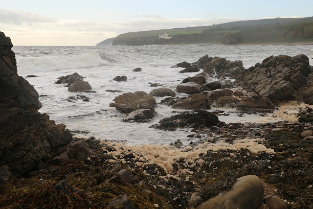
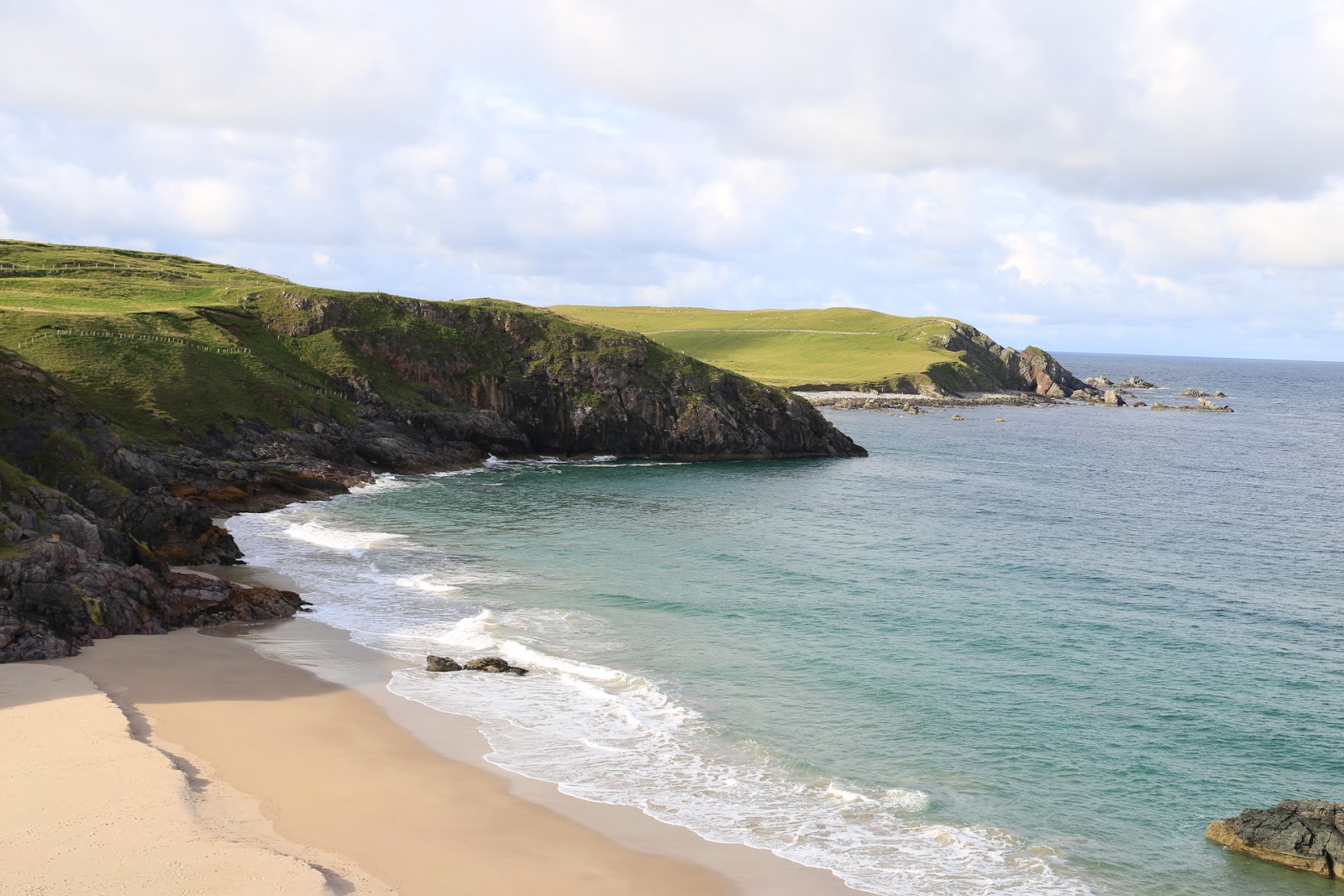
Sango Sands Camping Site is
situated along the cliffs above 1500m of beautiful yellow sandy beach, and with
rock stacks protruding from both the sand and the near shore adds greatly to
the character of the area. The site has its facilities spread far and wide and
hopefully the new facilities block being built will improve on this. One fresh
water tap for this sprawling site is certainly not enough and the pitches are
two close together. But views from the site make up for any failings and it was
worth an extra night to explore the area on foot.
Highly recommended is Smoo Cave that has the largest entrance of any sea
cave in the British Isles. Its 15m high while the main chamber is 60m by 40m.
On our visit the boat trip into the caves interior was cancelled due to the
weather but the very powerful waterfall inside the cave can be observed from a
purpose made viewing platform.
 |
| Smoo Cave. |
I had no idea that John Lennon had a cousin in Sangomore in Durness and
that he spent many happy holidays between the ages of nine and sixteen. In
August 2002 the area around the community hall was landscaped in conjunction
with BBC’s Beechgrove Garden. Part of the garden was dedicated as a memorial to
the Beatle and is the only permanent memorial dedicated to John Lennon.
 |
| John Lennon's Memorial. |
A mile or so in the opposite direction is Coco Mountain, a chocolate
cafe and factory that attract visitors from all over the world. While we were
there a mini bus full of American ladies descended on the place. Its located in
Balnakeil Craft Village that was originally built by the military as an early
warning station at the beginning of the 1950’s but was abandoned in 1954. These
typical concrete military buildings were left to rot that was until they were
taken over by some enterprising hippies in the late 1960’s and turned into a
Craft Village with a wide range of creative outlets.
Further on towards the vast sandy beach that forms Balnakeil Bay you
will find a derelict Chapel surrounded by a number of interesting tombstones.
An original Chapel was thought to have been established here in the 7th century,
but the existing ruins date back to 1619. Balnakeil House opposite the Chapel
was rebuilt in 1744 and is still used as prominent sheep farm today. Also there
is the ruin of a 19th century mill that was last used for grinding oats in
1912.
 |
| The Chapel. |
 |
| Balnakeil House. |
 |
| The Old Mill. |
The car park at Balnakeil Bay is the start of a 2.5-mile walk to Faraid
Head. Walk along the beach to the far end where a road heads up into the dunes.
Continue along this road until you reach the restricted MOD area; from here
follow the boundary fence to the right that will take you up to a viewpoint
marked with a cairn. Your return can be either the way you come or as an
alternative head down across the grass area and across the dunes to pick up the
roadway and then you can walk back across the beach. A stimulating and bracing
walk with some great views.
 |
| The Trig Point. |
 |
| View from the Trig. |
6th Stage: Durness to
Thurso.
Leaving Sutherland and driving across Caithness there is a change of
scenery, not quite so rugged and a bit more pastoral with a small amount of
conventional farm land. The route again involves driving on single-track roadways
for a lot of the way including an interesting drive around Loch Eriboll. Our
only stop off was at the Dounreay Nuclear Power Station which unfortunately
does not now have a visitors centre. The Power Station is being dismantled and
the three nuclear reactors are being decommissioned so until this work is
finished, late in the 2030’s, it is still the major employer in this area.
 |
| Dounreay Nuclear Power station. |
Thurso Bay Caravan and
Camping Park has a commanding position to the west of the town and
gives a panoramic view of the coastline from Scrabster and Holborn Head to
Dunnet Head via the Orkney Island of Hoy. But the site itself leaves a lot to
be desired. Most of the pitches were on very soft ground and if you got stuck
the camp bore no responsibility to get you out! The only hard standings had no
electric hook ups but fortunately we managed to park up on a small section of
the site's roadway next to the busy main road. The facilities were more like
‘public conveniences’, walls and floors were tiled which in turn made it always
feel cold and damp. So it was one of these rare times on this trip that we had
to use our own facilities.
 |
| View from site |
Thurso itself is an interesting wee town with a large population due
originally to the flagstone industry and latterly to nearby Dounreay. It’s the
largest town in Caithness with some nice shops, coffee bars, a large Tesco
Superstore and a Lidl opposite the Camping Park. It also has some visitor
attractions that can easily be seen in a day and on foot. A walk along The
Esplanade built in 1882 is a nice way to start your sightseeing tour. Before
you head over the pedestrian bridge stop at Wilson Street for a look around Old
St Peters Kirk. Situated in the old part of Thurso, it dates back to at least
1125 but has been disused since 1832. Its graveyard has abundance of old
tombstones and graves. The replacement Parish church St Peters and St Andrews
can be seen in all its Gothic slender across Sir John’s Square.
 |
| Old St Peters Kirk. |
 |
| The replacement Church. |
A very weird landmark is the sad looking remains of Thurso Castle a
Victorian Gothic ruin built in 1872 of which a large part was demolished in
1952 following a fire. The remaining structure can only be viewed from the
outside. If you walk around to what was the main entrance you will find the
gatehouse and associated lodge both in fair condition. From here you can easily
walk back into town and up to the campsite.
7th Stage: Thurso to John
O’ Groats.
John O’ Groats was a disappointment! Its a commercial tourist trap
that's rather unkempt and sad which people only tend to visit for a selfie in
front of the world famous fingerpost that signifies the furthest distance apart
of any two places on the UK mainland. The 876-mile distance from Lands End in
Cornwall has been used for all manner of record-breaking feats and to raise
money for all kinds of charities. The first person to walk the distance was
Elihu Buritt, an American, in 1865 so it's nothing new.
 |
| The famous Finger Sign. |
The settlement was named after a Dutch settler Jan de Groot who operated
a ferry to Orkney in the 15th century after the Orkney Island’s were annexed to
Scotland in 1472. There is still a passenger ferry running from John O’ Groats
to South Ronaldsay, the Pentland Venture carries up to 250 passengers in the
summer months and is very popular with tourist.
 |
| The Ferry to Orkney. |
The Dutchman was buried in Canisbay Kirk where in the vestibule you can
still see a memorial stone to him. It used to be under the floor of the church
but John Nicholson removed it in 1898 and embedded in the south wall, under the
vestibule window. Recently it has been cleaned and moved to where it’s positioned
now. The present church dates from the 17th century but there is evidence of a religious
site well before that time.
 |
| Canisbay Church. |
 |
| Jan de Groot's Memorial Stone. |
 |
| Inside the Kirk. |
From the John O’ Groat Caravan and
Camping Site you can walk right along the shore line up to Duncansby Head
via the Ness of Duncansby and passed the shell beaches where we saw a herd of
perhaps 30 to 40 seals frolicking in the shallows and, at times on the shore.
At the Head is one of Scotland’s 200 coastal lighthouses maintained by the
Northern Lighthouse Board. David A Stevenson built this Lighthouse in 1924 on the
most north-easterly point of the British mainland.
 |
| Another Stevenson Lighthouse. |
Walking south from the Lighthouse you can get the best views of the
Duncansby Stacks, the Long Geo of Sclaites a collapsed cave, and the Knee,
where at the right time of year you get to see Puffins, but unfortunately not
in September.
 |
| Duncansby Stacks. |
 |
| Long Geo of Sclaites. |
 |
| The Knee. |
I'm not sure I could recommend the camp site, its a transit site where
nearly all pitches are vacated each morning no one seems to want to stay too
long, two nights was even long enough for us. The nippy sweetie that ran the
site closed down most of the cold and uninviting facilities even before we
left.
8th Stage: John O’ Groats
to Dunbeath.
We really struck lucky with the Inver
Camping and Caravanning Site at Dunbeath, some of the best facilities during
our main trip were found on this site. It is licensed for 15 pitches including
8 hard standings and 14 electric hook-ups, warm and clean private shower rooms
with both sinks and toilets, laundry and drying room were also provided and the
site, although by the side of the A9, it was very quiet. Mrs Gwillim was both
friendly and helpful and does not over charge with a special offer for a 7
night stay.
 |
| Great facilities. |
On the way to Dunbeath it’s worth stopping at Wick. Its an interesting
wee town which has links to the great engineer Thomas Telford who was employed
c.1805 by the British Fisheries to build a harbour and a new town which was
called Pultneytown and is located on the south side of the Wick River. Wick
became the largest herring fishing port in Europe during the 19th century.
Pultneytown was eventually incorporated into Wick in 1902. There are lots to
see including the Wick Heritage Centre, unfortunately we did not have time to
explore further. For anyone who needs to stock up on supplies there is a very
large Tesco’s on the way into town and a Lidl on the way out, both had adequate
parking.
 |
| Pultneytown Habour. |
 |
| A street named after the great man. |
The village of Dunbeath has been by-passed by the world due to the
modern road bridge that was erected in 1989 and carries the fast moving A9. The
original bridge was built by Thomas Telford c.1815 and is still used to allow
access to both Dunbeath village and Portamin Harbour. The village has a fine
terrace of mid 19th century cottages, in one of which author and Scottish
nationalist Neil Gunn was born in 1891. Gunn was a prolific writer of novels
and is best known for Highland River (1937) and the Silver Darlings (1941).
Also in the terrace are a Spar Shop and a Hotel that is now closed and looks in
desperate need of renovation. Above the village you will find the Dunbeath
Heritage Centre situated in the old village school where Neil Gunn started his
education, but be aware its not always open when it says it is!
 |
| Neil Gunn was born in this 1st terrace house. |
 |
| The original Telford bridge. |
 |
| The one and only shop. |
 |
| Ex School and now the Heritage Centre. |
At the mouth of the Dunbeath Water is the Portamin Harbour originally
built in the early 1880’s to cash in on the herring boom. It is now a very
tranquil place where you can still see an old fishing store, an icehouse and a
salmon fisherman’s bothy, all in remarkable condition. Also there a wee museum
that gives a brief history of the local fishing boats. On the harbour side is
an attractive statue depicting Kenn and the Salmon, celebrating the life of
Neil Gunn, you also get a great view of Dunbeath Castle perched precariously on
the edge of the cliffs. There is a picnic area at the end of the harbour road
with benches to sit and soak up the wonderful relaxing atmosphere and offers views
of seals swimming in the sea.
 |
| The Harbour. |
 |
| Fishing Store. |
 |
| Kenn and the Salmon. |
 |
| The view from Portamin Harbour. |
 |
| A place to watch seals while relaxing and having a picnic. |
Dunbeath Castle is in private ownership but I believe you can see the
gardens in August and it can be hired for weddings. A descendant of Charles
Edward Stuart’s personal physician, Mr Stuart Wyndham Murray Threipland, bought
the 30000-acre estate in 1997. The Murray Threipland’s were one of the Stuart
royal family's strongest sympathisers with the Old Pretender staying at Fingask
Castle, there ancestral home, during his 1715 uprising. The Scots Baronial
style castle dates back to 1428 but has been remodelled many times since by its
many different owners.
 |
| The driveway up to the castle. |
 |
| Dunbeath Castle has links to the Jacobites. |
To sample the vast remoteness of Caithness I would suggest a walk up the
Dunbeath Strath Heritage Trail. (A Strath is a large river valley that’s wide
and shallow.) Along this route there was a thriving community until the
Highland Clearances emptied the land. You will see plenty of evidence of this
with the ruined crofts littered about the countryside after the forced land
clearances. The first point of interest is the Meal Mill, built between 1850and
1860 and was in operation until 1950, it now houses a publishing company
therefore the building is in very good condition. Just before a rather scary
footbridge took us across the Houstry Burn, which was in full flow, there are
some prominent stonewalls on the left that are believed to have been part of a
monastery. This is mentioned in Neil Gunn’s ‘The Silver Darlings’. Next you get
a chance to visit a well-preserved Iron Age broch dating back some 2500 years.
It has been alleged that this was the broch besieged by Brude the Pictish king
in 680 AD. An informative notice says that the windowless tower may have stood
as high as 9m. In the summer of 1990 the local Preservation Trust under took
some reservation work which makes it the best preserved of several broch’s in
the Strath.
Next you come to a fine gorge known as the Prisoners Leap. To reach this
you have to come off the path and follow the deer fence towards the burn. Its
here that Ian McMormack Gunn jumped the gorge to earn his freedom after being
imprisoned in Forse Castle by his enemies the Keith's. They agreed that they
would release Gunn if he successfully leaped over the gorge. With a tremendous
show of courage and strength he succeeded in securing his freedom. It is
alleged that because Gunn was an orphan and raised on ‘hindmilk’ (the breast
milk at the end of a feed) he was able to complete the feat.
 |
| The site of the 'Prisoners Leap |
As I mentioned before, the remoteness of the country side is due greatly
to the ‘clearances’ and there is plenty of evidence of the old ruined
settlements on the walk but just after the site of Gunn’s leap can be found a
good example of a old croft, barn and cornkiln that would have formed part of a
larger crofting settlement.
 |
| The old croft settlement. |
 |
| Nothing left of the once thriving communities. |
 |
| The beautiful country side on the Strath Trail. |
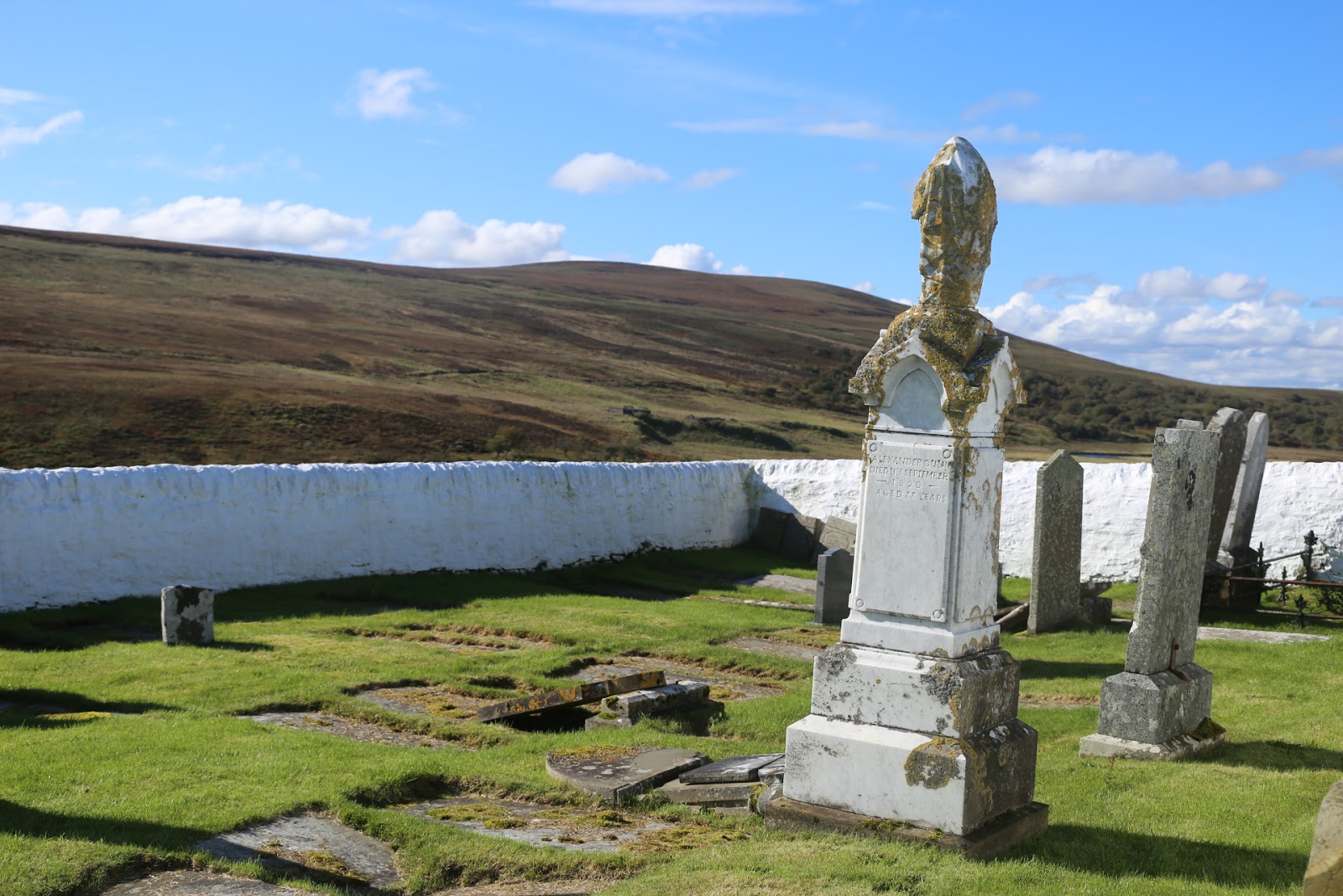
The white cemetery of Tutnaguail was the culmination of our walk. This
strangely placed burial ground is 3 miles from Dunbeath village and located in wide-open
heather lands beyond any real civilisation. Although this was featured in Neil Gunn’s
novel Highland River I could find no information about the cemetery.
 |
| The mysterious white walled cemetery. |
8th Stage: Dunbeath to
Dornoch.
The coastal route between Dunbeath and Dornoch takes you through some
beautiful villages, places like Helmsdale, Brora and Golspie, before you turn
off the A9 just after Evelix for Dornoch the former county town of Sutherland.
These days its best known for its championship golf course but there's much
more to interest an inquisitive traveller than a round of golf.
 |
| Back on the A9. |
 |
| The picturesque houses in Dornoch. |
In my opinion the first place to visit is the History Links Museum
situated behind the Dornoch Castle Hotel. The museum focuses on local history
including displays that cover local geology, the Picts, the Cathedral, Andrew
Carnegie The First Sutherland Volunteers and the development of the golf
course. Also you can see a films on Sutherland in 1950 and a very interesting
one on The Dornoch Light Railway which helped develop the area as a tourist
resort, unfortunately the branch line closed in 1960.
 |
| The local Museum. |
 |
| The defunct branch line. |
 |
| The Old Jail and Information Centre. |
 |
| The Castle. |
 |
| Another hot chocolate! |
The centre point of this architecturally pleasing wee town is the
Cathedral. It was Gilbert de Moravia Bishop of Caithness who in 13 century, at
his own expense, had the cathedral built. Consecrated in 1239 it was destroyed
by fire during a clan feud between the Earls of Caithness and Sutherland in
1570. Now the parish church, it was restored by Elizabeth, Duchess of
Sutherland between 1835-37. There are some very impressive examples of stained
glass windows, three of which commemorate the steel magnate and philanthropist
Andrew Carnegie who lived at Skibo Castle nearby who, along with his daughter
Margaret, was very generous to the church providing money for both organ
repairs and rebuilding as well as the lighting. Also its were Madonna married
film director Guy Richie in 2000. It's a church with both beauty and warmth and
one that's been very well maintained over the years.
 |
| The Cathedral. |
 |
| The original building burnt down in 1570. |
Another point of local history is that Dornoch was the last place in
Scotland to have a person to be burnt to death as a witch. Janet Horne was a
lady's maid before she married; by 1727 she was old and confused. It was
reported that the old lady was using witchcraft to turn her daughter, who had a
deformed hand, into ‘the devils pony’. Both mother and daughter were imprisoned
in Dornoch where they were tried and found guilty of witchcraft and sentenced
to death. The day after Janet was stripped, rolled in tar and placed in a
barrel. She was paraded through the streets and then burned alive. A stone has been
placed next to the golf links and mark’s the place she died. The location of
the stone occupies a private garden but
can still be seen.
 |
| The last place a witch was burnt to death in Scotland. |
 |
| The spirit of Janet Horne. |
A worth while day out is at Dunrobin Castle the historic home of the
Earls and Dukes of Sutherland, the first of whom was responsible for the land
clearances leading to hardship and the emigration of the Scottish people to the
Americas and Canada. The castle itself is a grand building, a show of wealth
and privilege that has been altered/added to three times since 1275. The staff
are very helpful especially the guide that was in the 10000 book library who
spent some time educating us on the history of the castle and of the modern
family. Between the castle and the sea are landscaped gardens and a summerhouse that
houses prime examples of the brutality of the upper classes - those of a animal
loving disposition should not visit this building! As usual a complete day
should be set-aside for your visit and if you arrive early parking of large
vehicles is not a problem.
 |
| Dunrobin Castle. |
 |
| The front entrance and car park. |
 |
| The Gardens. |
 |
| The brutality of the upper classes. |
 |
| One very interesting exhibit in the Summer House. |
The Dornoch Caravan Park is
situated between sand dunes and two golf courses one of which is the world
renowned Royal Dornoch, therefore the pitches are very open to the elements and
believe me there are some very strong winds at times! The site is very large
with a lot of static caravans; the facilities are cleaned twice a day, although
they not particularly warm!
 |
| Plenty of room on this site. |
 |
| The Beach and .... |
 |
| ...the shore in front of the camp site. |
This stop marked the end of our ‘North Coast’ travels, all we had left was to drive back to Inverness although
we decided not to stay in the city this time but drive on to Stirling for a few
days before returning home.
I'm sure the local businesses are happy, economy wise, to have attracted
thousands more visitors to the area due to the hype piled upon the NC 500 but
the large amount of people en route and pitched on the sites spoils the
normally quiet and tranquillity of touring around Scotland. I'm sure that a lot
of the tourist that travel on the route don't stop anywhere long enough to
spend money and enjoy many of the points of interest that can be visited
following an interesting walk or a short bike ride. There does seem an
abundance of ‘boy racers’ in sports cars, lots of motorcyclist and of course
arm waving idiots in Motorhome’s who never speak to you when pitched on site during
their single night stops.
The campsite's varied between the good and not so good and I have dealt
with each site in the body of the main blog.
Weather is always a problem when touring Scotland even in the summer
months, but after living here for 25 years one tends to get use to it although
the abundance of wind, rain and low lying cloud did somewhat spoil our
enjoyment of the beautiful scenery that was on offer and at times did make
walking and cycling a wee bit uncomfortable.
I have read that people prefer the west coast and find the east coast
uninteresting which is a lot of nonsense because each side of the country has
its own attractions and if people took the time to explore then I think they
would have to agree that the east side has just as much to offer as the west.
We very much enjoyed the three and a half weeks spent touring what is now
globally known as the North Coast 500 and if like us you make the most of your
trip by making plenty of stop overs and get off your backsides and explore each
area then I'm sure you would enjoy the trip far more. But be warned this route
is going to get even more popular which, like Skye, is obviously going to suffer
infrastructure problems if more money is not invested in improving roads and
facilities.


A very good read thank you. We did the N500 this summer and did not share a single place with you!!
ReplyDeleteThank you for kind comment. Sorry we missed you 😊😊😊
DeleteHi
ReplyDeletenice article
I’m fortunate that my job takes me all round the Nc500. Agreed, great for business, and pressure on this remote area which had poor infrastructure even before NC500 ( best roads are EU funded). Investment is needed but once the roads are widened and buildings go up the very reason for people visiting disappears, remote, wild, unpopulated wild lands. It’s a catch 22 indeed. Thanks for sharing.
This comment has been removed by the author.
ReplyDeleteFabulous read, looking forward to our adventure there next spring!
ReplyDelete