
Bunree, Onich, Fort William.
First stop on this years Autumn Trip was at the wee Bunree Club Campsite. We had a decent size pitch, right on the edge of Loch Linnhe with a beautiful view across to Ardgour peninsula and Corran, a small settlement to the east of Sunart. At the Corran Narrows on Loch Linnhe there is a ferry crossing which normally takes vehicles along with passengers, but at present it only runs a passenger ferry as the main ferry is in need of essential repair.


The trip across takes no more than five minutes and is a crucial link between the main A82 serving Inverness, Fort William and Glasgow with the other wise extremely remote Morvern and Ardnamurchan peninsula’s use of the main ferry, when working, saves over an hour from land routes between Ardgour and Corran.


Its well worth a trip across to the slipway at The Inn at Ardgour, which was originally the ferryman’s cottage. Turn right from the ferry for the Ardgour Church built by the busy civil engineer Thomas Telford. Just passed the church is the Ardgour Brewery.


Walk back along the shore past the slipway until you come to the Corran Lighthouse built in 1860 by Thomas and David Stevenson. Which has been converted into a holiday lodge, that will cost you over £300 per night, so we were unable to get very close. Returning across the narrows we collected our bikes and cycled back to the campsite.


After a overcast morning it turned into a lovely afternoon, so we took the opportunity to climb up to the Inchree Waterfall. Turn left out of the campsite road, across the busy A82 and take the road opposite up to the Inchree Car Park. From here follow the red markers. The path is easy but gets slightly steeper the nearer the waterfall you get. A number of viewing platforms have been provided along with benches, so the weary can have a break. The waterfalls are spectacular and well worth a 2.5 mile walk from the campsite. Continue on to the top were you join the Forest Road, turn left and follow Wades Road back to the car park and from there return to Bunree.


the Corran Ferry Junction you can get a N44 bus that will take you into Fort William Bus Station next to the railway station, a short walk will take you into the town centre. We have been to Fort William twice before so nothing new. A mooch around the shops and lunch in the Kilted Camel followed by a visit to St Andrews Church.


St Andrews Episcopal Church was built between 1879 and 1884, its principal architect was Alexander Ross. The entrance boosts a fine pair of doors with intricate carvings by Harry Hems. This church has a sumptuous interior, richly decorated in gothic stye..

A 914 City Link Bus took us back to the Ferry Junction from which we walked back to the site in some lovely late afternoon sunshine. A vey nice end to our 4 day holiday at the well presented and clean C&MH Camp Site.
Killin. Perthshire.

Killin is a historic conservation village in Perthshire in the Highlands of Scotland situated at the western head of Loch Tay and is the central settlement of the region of Breadalbane which, like its neighbour Kenmore, is under treat from Americans who want to turn Scotland into a rich mans playground.


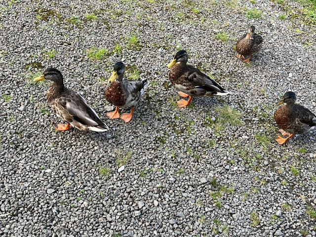
Above the north end of the village is the Maragowan Club Campsite surrounded by the hills that make up the Ben Lawers National Nature Reserve. With some 97 well spaced pitches and the normal clean facilities its an ideal stop off the explore the surrounding area, that is of course if it ever stops raining. Our pitch was on the edge of the River Lochay so we get plenty of visits from the local ducks who seem to appreciate the weather better than we do.
 |
| Before the heavy rain. |
 |
| After the heavy rain. |
A walk through the village will take you down to the Bridge of Dochart and the lovely Falls. Which is one of the reasons why this area is a centre of tourism. Some nice shops, Hotels and restaurants and a sizeable Co-Op complement the village.

Our first bike ride was on a lovely quite route known as the Lochay Loop which takes you up one side of the Glen Lochay past the Moirlanich Longhouse, more of which later, up the the power station and back down the other side of the glen.
As i said we past the Longhouse on our bike ride but as it only has restricted opening on certain days between 2 and 5pm we cycled back in the afternoon.


Moirlanich Longhouse is a National Trust Property so free to members. It was built in the early 1800s when the population of Glen Lochay was reaching its peak. It was originally the home of the Robertson family, until the last member left in 1968. The visit to this couck-frame dwelling give you a glimpse of rural life in this area, in the not to distant past with its original furniture including box beds, scotch dresser and farm implements which were displayed in the ‘three cattle’ byre. its always surprising the amount of history that a visit to a property like this one can evoke.


The following day the heavy rain stopped in the afternoon so we decided to take a walk down Pier Road, first to explore 17th century Finlarig Castle, which sits strategically north of the village. Built in 1629 by ‘Black’ Duncan Campbell the castle is now in rather a dangerously ruinous state. Its history includes various visits by Rob Roy MacGregor and his men. Near the castles north wall is a stone lined pit which, legend has it, was used for beheading prisoners of noble blood. Commoners did not get the same privilege, they were hanged on a nearby oak tree - no evidence of either punishment are left to see!

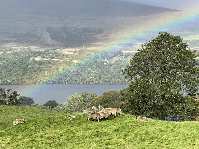
Continuing further on down Pier Road you can walk across to the head of Loch Tay and admire the beautiful scenery that surrounds this famous freshwater Loch. Its the sixth largest in Scotland. The Campbells held most of the land in the area until the late 1800s when they began to sell of the land, but before doing so undertook clearances that involved two-thirds of the local population. In the 1950s the largest landowner was the National Trust for Scotland.


We went on to discover what was the Loch Tay railway station which comprised a single platform. A loop was provided that continued to an engine shed that is now a private house. The station closed to passengers in September 1939 but as the engine shed was still located here the line remained in use until September 1965. You can follow the route of the railway across the iron bridge back into the Killin Village.


Killin Parish Church was built in 1744 to replace an older building that was originally behind the Killin Hotel. It was built to seat 600 people, which must have been a large part of the local populace. Interestingly enough the bell, dated 1632, is still in use today.

Rained non stop the following day and continued to rain all night. We woke up next morning to find the Motorhome surrounded by water, The river in front of us was virtually over the banking, so we moved the van back off of the original pitch. It was at this time that the site staff informed us the if the water got any higher the campsite would have to be evacuated! Thankfully the rain finally stopped and the river stared to recede.
There is a quiet road that runs along the south side of the Loch Tay which is ideally suitable for a bike ride. Its a 8 mile run to Ardeonaig, a small hamlet that boasts a hotel/restaurant which go course was closed the day we went. back in the day you could catch a ferry from here across the Tay.

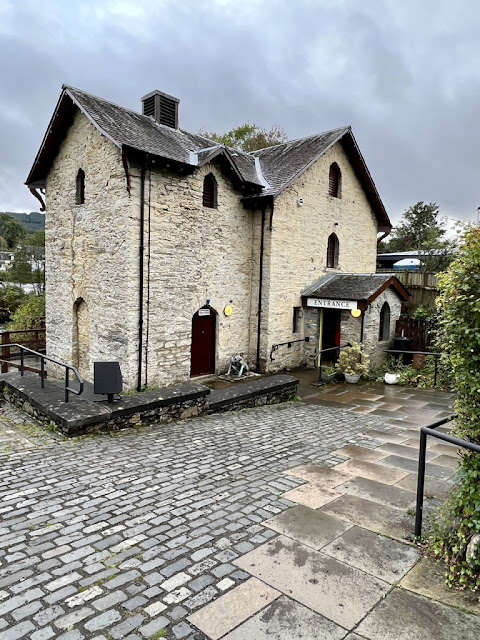

The River Dochart may be short, but its very powerful. It was St. Fillan who decided to build a meal-grinding mill here because of the force of the ‘scouring’ river. The mills that now stands here was built around 1840, which became a woollen mill up until 1939.


Fillan was a noted healer and a set of his healing stones can be seen in the mill. Each stone has a different shape and is to have been used in curing a particular part of the body by rubbing the affected area. A thanks must go to Cheryl Macleod for showing us the stones.
The Woods Caravan Park. Fish Cross. Clackmannanshire.

A two night stopover on our way to Yellowgraig was at one of the many Caravan and Motorhome Clubs Affiliated Site the facilities were clean, modern and warm. This popular site was upgraded in 2018 with a new reception area that stocks a good selection of basic goods. There s a restaurant next door called the Woodman which serves very good food at a resolvable price. The land the site is now on was originally a brick works, and across the road was a mining area.

One side of the site is framed by the beautiful Ochil Hills, which we had explored previously when we camped just outside of Stirling.

Well worth another look was the rather strange Sauchie Tower. The original building had six storeys, a courtyard and an outer wall on at least two sides. A turnpike stair provided access to all stories. the lower floors were used for storage and above was the Great Hall with 'bedchambers' on other floors. It was built around 1412 by Sir James Schaws whose son became Governor of Stirling Castle in 1460.

Although tricky to find your way across the Alloa golf course the 4 mile walk to the Gartmorn Dam was well worth while. Situated in Gartmorn Country Park and local nature reserve. The Dam is the oldest man-made reservoir still operating in Scotland which was built in 1713 by the Earl of Mar in an ambitious scheme to use water power to drive pumps in his coal mines. The country park which surround the reservoir incorporates facilities for picnicking, fishing, birdwatching and walking.

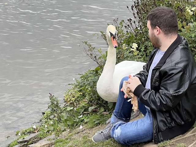
As you can see from the above photos the waters also incorporates swans. The young man, Ewan, who is known locally as the “swan whisperer’ regularly feds these gracious and majestic creatures.
Yellowcraig. North Berwick. East Lothian.

To my mind there’s nothing better than a long walk along a beach, that lovely smell from the sea lapping the shore. It evokes a feeling of freedom and Broad Sands Beach is an ideal place to test this theory.

Yellowcraig Camp Site is only a short walk from the beach, which borders a coastal area of forest, and grassland and also incorporates a section of the John Muir Way and is partly within the Firth of Forth Site of Special Interest.


Head east once joining the beach and a three mile walk will take you to North Berwick. Only 25 miles from Edinburgh the area is very up market with property prices to match. Narrow streets with some nice shops, restaurants and coffee bars. Originally a fishing port in the 19th century. With the arrival of the railway in 1850 it became a tourist resort encouraging modern day visitors to enjoy the golf course, the angling centre, a sports centre/swimming pool and the seabird centre from which you can arrange a boat trip around the Bass Rock. Follow the John Muir Way back to see how the other-half live.


For a real local treat follow the John Muir Way west signposted to Dirleton across farm land where we witnessed the harvesting of a very large crop of Brussel Sprouts which once the harvesting was complete we were told we could help our selves, Mrs Matthews jumped at the chance being one of the only people i know who actually likes this vegetable, and not only at Christmas!!


Dirleton is regarded as one of Scotlands most picturesque villages with neat rows of cottages around a large village green, which itself is dominated by Dirleton Castle.


For centuries, according to the official Historic Scotland guide, the Castle stood close to the centres of royal power and the border with England. This brought influential lords and ladies, as well as invading armies, to its gates. From the1200s to the 1600s, the castle was lived in by the families of de Faux, Haliburton and Ruthven. These nobles held prominent places in the Scottish court, exploiting their connections and making the most of political opportunities to gain high office. Walter Haliburton was appointed Lord High Treasurer and William Ruthven became the 1st Earl of Gowrie. Throughout the 1600s the castles fortunes declined. The Ruthvens were disgraced and their titles forfeited. Soon after six suspected witches were imprisoned in the castle. Then, on 9th November 1650, the castle was besieged by the troops of Oliver Cromwell and left in ruins. After this it was passed to the Nesbit family in 1663, but was subsequently abandoned as a residence in favour of a new and more comfortable house at Acherfield.


Now in the care of Historic Scotland we can explore the ruins and admire the beautifully landscaped gardens.


Before leaving the village to collect the Brussel Sprouts its worth having a look at the parish church dating from 1661, extended in 1825. In 1971 the church was designated as a Category A listed building. In front of of the church is the Old School house which is in private hands and is being renovated.

Before returning to the camp site we extended our work to Acherfield for refreshments at the garden centre to end our August 2023 Trip. Next stop is to visit our family.
No comments:
Post a Comment